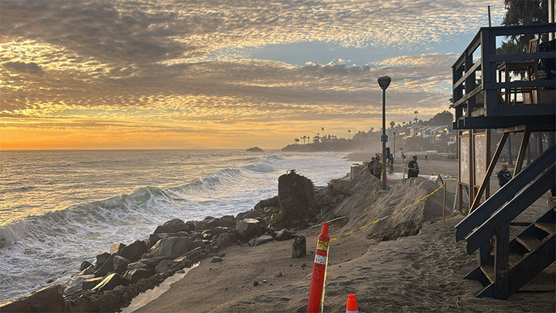
Rockpile Beach is the south-end pocket below Heisler Park where Laguna’s coastline turns dramatic fast: shallow reef, loud sets, and tidepool texture that changes by the hour. Many visitors come to observe rather than swim because the reef sits close to the surface, shorebreak can be heavy, and the sand “disappears” at higher tides. If you time it right and treat wet rock like a hard boundary, this spot delivers some of the best reef views and wave watching in town.
Rockpile Beach Overview
Rockpile Beach is a “look first” stop. Mid-to-low tide reveals more structure and intertidal detail; higher tide pushes wave wash farther up the rock and tightens the safe walking area. Because the pocket is small, it can feel busy even when the rest of Heisler has room—think of it as a feature on a coastal walk rather than an all-day swim session.
Access, Parking, And Facilities
Use signed paths and stairs from the south end of Heisler Park to reach the sand. Parking is primarily metered along Cliff Drive, with downtown lots a short walk away. Bathrooms and outdoor showers are in the park above, but there are No public restrooms at this beach and No outdoor showers at this beach at sand level. Pack light for the stairs, and plan your visit around tide windows so you’re not fighting wave wash on the rocks.
Best Time Window At Rockpile Beach
A dropping mid-to-low tide is the easiest window for exploring and photos. You’ll get more dry sand, clearer reef texture, and better safety buffers. If the tide is rising and sets are running up the reef, shift your time to bluff-top viewing and skip the temptation to “just step a little farther out.” Early mornings often feel calmer and cleaner, and weekdays usually give you more room to work.
Conditions And Safety
This is a shallow, rocky reef, and it behaves like one. Even modest south swell can create punchy shorebreak, and surge channels can fill quickly. The safest pattern is simple: watch several full set cycles before you move closer, keep kids well back from wet areas, and avoid slippery algae-covered surfaces. If you’re standing on low rock, assume a bigger set can arrive without warning.
Rockpile Beach isn’t a beginner swim spot. On rare calm mornings, experienced snorkelers may work the edges, but most visitors are better off tidepool observing, wave watching, and walking the path. If you want actual water time, choose a softer-entry cove and use this pocket as your scenic stop.
Tide Pools, Etiquette, And Protected Coastline
Laguna’s coastline is marine protected citywide—no collecting of marine life, rocks, or shells, and no fishing along Laguna Beach’s shoreline. Treat tidepools as look-only habitat: hands off wildlife, step only on dry rock, and keep your footing slow and deliberate. Good etiquette here is low-key: speakers off, trash packed out, and space given to anyone watching sets or taking photos.
Things To Do
- Tidepool Observing: Go at low tide, move slowly, and treat every wet surface as slippery.
- Wave Watching: Sets refract across the reef and bend toward Bird Rock, making this a standout “watch the ocean work” spot.
- Photo Walks: Mid-to-low tide delivers the best texture—reef color, reflections, and layered rock lines.
- Heisler Loop: Pair this stop with the path above for a multi-cove outing without moving your car.
Walkable Nearby Beaches From Rockpile
If you want more sand and softer entries, walk north to Picnic Beach or Diver’s Cove Beach. For another rocky panorama and a different angle on the Heisler shoreline, continue to Fisherman’s Cove Beach. You can also browse additional options in our Beaches Guide.
Plan With Real-Time Conditions
Tide timing is the difference between an easy explore and a tight, surgey shoreline. Check tides and live swell before you go so you can pick the safest window.
NOAA Tide Predictions | NOAA Buoy 46285 (Live Swell & Wind)
Photography Tips
Work mid-to-low tide for tidepools and reflections, and use a polarizer to cut glare on clear days. For wave studies, shoot from dry, higher vantage points and wait for sets that refract diagonally across the reef. At sunset, Bird Rock silhouettes and the palm line above Heisler make an easy frame. If water is reaching your shoes, you’re too close—back up and keep the shot safe.
Visitor Reminders
Pack out everything you bring, keep noise low near the bluff, and give lifeguards and Marine Safety teams clear lanes when they’re moving through. If conditions build, relocate to higher ground—set waves can arrive suddenly even when the ocean looks calm between sets. When in doubt, sit back and enjoy the view from the bluff, then hop to a calmer cove on the path.